Articles dans des revues internationales ou nationales avec comité de lecture non répertoriées dans les bases de données internationales
- Brasebin M., Perret, J., Mustière S., Weber C. (2017) 3D urban data to assess local urban regulation influence, Computers, Environment and Urban Systems, 2017, ISSN 0198-9715, https://doi.org/10.1016/j.compenvurbsys.2017.10.002.
[
Article]
- Brasebin, M., J. Perret, S. Mustière and C. Weber (2016) A Generic Model to Exploit Urban Regulation Knowledge, ISPRS International Journal of Geo-Information, vol. 5, n. 2, pp. 14, doi:10.3390/ijgi5020014.
[
Article]
- Brasebin, M., J. Perret, S. Mustière and C. Weber (2014) Simuler les évolutions urbaines à l'aide de données géographiques urbaines 3D, Revue Internationale de Géomatique, vol. 24, n. 2, pp. 159--180. [
Article]
- Brasebin, M., J. Perret and C. Haëck (2011) Un système d'information géographique 3D pour l'exploration des règles d'urbanisme - application à la constructibilité des bâtiments, Revue Internationale de Géomatique,
vol. 21, n. 4, pp. 533--556. [Article]
Communications avec actes dans un congrès international
- Brasebin, M., S. Christophe, F. Jacquinod, A. Vinesse and H. Mahon (2016) 3D Geovisualization and stylization to manage comprehensive and participative Local Urban Plans, 11th 3D Geoinfo Conference , pp. 83--91,
ISPRS Ann. Photogramm. Remote Sens. Spatial Inf. Sci., IV-2-W1, doi:doi:10.5194/isprs-annals-IV-2-W1-83-2016. [Article, Presentation]
- Brasebin, M., E. Buard, S. Christophe and F. Pelloie (2015) A knowledge base to classify and mix 3D rendering styles, 27th International Cartographic Conference (ICC'15), Rio de Janeiro, Brazil., doi:http://www.icc2015.org/abstract,422.html.
[
Article, Presentation]
- Brasebin, M., J. Perret and R. Reuillon (2015) Stochastic Buildings Generation to assist in the design of Right to Build plans, Joint International Geoinformation Conference 2015 - 3D GeoInfo. [Article,
Presentation]
- Meneroux, Y. and M. Brasebin (2015) Towards a generic method for buildings-parcels vector data adjustement by least squares, 9th International Symposium on Spatial Data Quality (ISSDQ'2015). [Article]
- He, S., J. Perret, M. Brasebin and M. Brédif (2014) A stochastic method for the generation of optimized building-layouts respecting urban regulation, ISPRS/IGU Joint International Conference on Geospatial Theory,
Processing, Modelling and Applications 2014, Advances in Spatial Data Handling and Analysis - Select Papers from the 16th IGU Spatial Data Handling Symposium, Springer. [Article, Presentation]
- Brasebin, M., J. Perret, S. Mustière and C. Weber (2012) Measuring the impact of 3D data geometric modeling on spatial analysis : illustration with Skyview factor, 3U3D2012: Usage, Usability, and Utility of
3D City models. [Article, Presentation]
- Brasebin, M., J. Perret and C. Haëck (2011) Towards a 3D geographic information system for the exploration of urban rules: application to the French local urban planning schemes, 28th urban data management symposium
(UDMS 2011). [Article, Presentation]
- Buard, E. and M. Brasebin (2011) Visual exploration of large animal trajectories, 25th International Cartographic Conference (ICC'11). [Article, Presentation]
- Brasebin, M., B. Bucher and C. Hoarau (2010) Enriching a 3D world with synthetic and visible information about the distribution of points of interest, 5th 3D GeoInfo Conference (3DGeo'10). [Article,
Presentation]
- Brasebin, M. (2009) GeOxygene: An Open 3D Framework for the Development of Geographic Applications, 12th International Conference on Geographic Information Science (AGILE). [Article,
Presentation]
- Bucher, B., M. Brasebin, E. Buard, E. Grosso and S. Mustière (2009) GeOxygene: built on top of the expertness of the French NMA to host and share advanced GI Science research results, International Opensource
Geospatial Research Symposium 2009 (OGRS'09). [Article]
Communications avec actes dans un congrès national
- Brasebin, M., P. Chapron, G. Chérel, M. Leclaire, I. Lokhat, J. Perret and R. Reuillon (2017) Apports des méthodes d’exploration et de distribution appliquées à la simulation des droits à bâtir, Actes du Colloque
International de Géomatique et d'Analyse Spatiale (SAGEO 2017). [Article, Presentation]
- Brasebin, M., J. Perret, S. Mustière and C. Weber (2012) Simuler les évolutions urbaines à l’aide de données géographiques urbaines 3D, Actes du Colloque International de Géomatique et d'Analyse Spatiale (SAGEO
2012). [Article,
Presentation]
- Brasebin, M., J. Perret and C. Haëck (2010) Un système d'information géographique 3D pour l'exploration des règles d'urbanisme, Actes du Colloque International de Géomatique et d'Analyse Spatiale (SAGEO 2010) [
Article, Presentation]
Thèse soutenue
- Brasebin, M. (2014) Les données géographiques 3D pour simuler l'impact de la réglementation urbaine sur la morphologie du bâti, Thèse de doctorat, spécialité Sciences et Technologies de l'Information Géographique,
Université Paris-Est, apr 2014. [These, Presentation]
Conférences données à l'invitation du comité d'organisation dans un congrès national ou international
- Brasebin, M. (2018) Systèmes d'information géographique 3D, leurs
usages et la simulation de formes urbaines, Séminaire du laboratoire LASTIG équipe Strudel, 11 décembre 2018. [Presentation]
- Brasebin, M. (2018) Simulation 3D de la constructibilité et utilisations pour l’aménagement, Séminaire du laboratoire LOCIE, Université de Savoie-Mont Blanc, 6 juillet 2018. [Presentation]
- Brasebin, M. (2017) Usages des données topographiques multi-dimensionnelles pour la simulation des évolutions - Travaux de l’axe de recherche sur les dynamiques spatiales, Conférence GOPRO 2017, ENS - Lyon,
13 - 14 décembre 2017. [Presentation]
- Brasebin, M. (2015) PROJEKT E-PLU, TAGUNG CADASTRESUISSE 2015 "GIS – Jetzt 3D!", 10 juin 2015. [Presentation]
- Brasebin, M. (2015) Projet e-PLU, Journée du Cadastre Suisse "Maintenant, pensez SIG 3D!", 10 juin 2015. [Presentation]
- Brasebin, M. (2014) Apport des données géographiques 3D fines pour l’évaluation de l’influence de règles d’urbanisme, Atelier Sageo 2014 AP 3D et usages, nov 2014. [Presentation]
- Brasebin, M. (2013) Les données géographiques 3D pour simuler l’impact de la réglementation urbaine sur la morphologie du bâti, 1er Séminaire de l’Action Prospective SIG 3D, mai 2013. [Presentation]
- Brasebin M. (2012) Usages des données géographiques 3D pour analyser les évolutions urbaines, Séminaire du laboratoire Image , Ville , Environnement, Strasbourg, jan 2012. [Presentation]
- Perret, J., M. Brasebin and B. Dumenieu (2012) Usages des données urbaines multi-dimensionnelles, SIG urbains, Sageo 2012, nov 2012. [Presentation]
Ouvrages scientifiques (ou chapitres de ces ouvrages)
- Brasebin, M., J. Perret and R. Reuillon (2017) Stochastic Buildings Generation to Assist in the Design of Right to Build Plans, pp. 373--384, Advances in 3D Geoinformation, Springer International Publishing,
doi:10.1007/978-3-319-25691-7\_ 21. [Article]
- Bucher, B., M. Brasebin, E. Buard, E. Grosso, S. Mustière and J. Perret (2012) GeOxygene: Built on Top of the Expertise of the French NMA to Host and Share Advanced GI Science Research Results, Geospatial Free
and Open Source Software in the 21st Century, chap. 2, pp. 21--33, Bocher, Erwan and Neteler, Markus Ed., Lecture Notes in Geoinformation and Cartography, Springer Berlin Heidelberg, doi:10.1007/978-3-642-10595-1\_ 2 [Article]
- Grosso, E., J. Perret and M. Brasebin (2012) GEOXYGENE : une plate-forme interopérable pour le développement d'applications géographiques, Développements logiciels en géomatique : innovations et mutualisation,
chap. 3, Bénédicte Bucher et Florence Le Ber Ed., Hermès - Lavoisier [Article]
- Grosso, E., J. Perret and M. Brasebin (2012) GEOXYGENE: an Interoperable Platform for Geographical Application Development, Innovative Software Development in Gis, chap. 3, pp. 67--90, John Wiley \& Sons, doi:10.1002/9781118561928.ch3.
[
Article]
Articles dans des revues internationales ou nationales sans comité de lecture
- Brasebin, M. (2016) Les données géographiques 3D pour simuler l'impact de la réglementation urbaine sur la morphologie du bâti, Cartes et Géomatique - Revue du Comité Français de Cartographie, n. 227. [Article]
- Brasebin, M., S. Christophe, E. Buard and F. Pelloie (2015) A Knowledge Base to Classify and Mix 3D Rendering Styles, Brazilian Society of Cartography, Geodesy, Photogrammetry and Remote Sensing, vol. 5, n.
67, pp. 1067 --1077, doi:issn:1808-0936 (Special Issue 27th ICC). [Article]
- Brasebin, M., S. Christophe, E. Buard and F. Pelloie (2015) Base de connaissances pour gérer des styles de rendus 3D, Cartes et Géomatique, n. 226, pp. 51--59. [Article]
- Buard, E. and M. Brasebin (2012) Exploration visuelle de trajectoires de grands animaux, Cartes & Géomatique, vol. 211, pp. 101--114. [Article]
- Ruas, A., J. Perret and M. Brasebin (2012) Saisies et représentations de l’espace urbain, RéférenceS : revue du commissariat général au développement durable, pp. 65--74. [Article]
Productions de vulgarisation
- Brasebin, M. and S. Christophe (2015) PLU++ Vers un plan local d’urbanisme plus intelligible et plus participatif, journées de la Fédération Nationale des Agences d'Urbanisme, oct 2015. [Presentation]
- Brasebin, M. (2009) GeOxygene: une plate-forme de développement 3D , Mappemonde, vol. 96 (http://mappemonde.mgm.fr/num24/fig09/fig09405.html). [Article]
Communications orales sans actes dans un congrès international ou national
- Chapron, P., M. Brasebin, J. Perret and R. Reuillon (2017) Exploration de l’influence de la réglementation urbaine locale sur la morphologie des formes bâties par simulation distribuée, 13e Rencontres de Théo
Quant. [Article]
- Colomb, M., M. Brasebin, J. Perret and C. Tannier (2017) Couplage de deux modèles de simulation (MUP-City et SimPLU) pour évaluer l'articulation entre différentes échelles de documents d’urbanisme, 13e Rencontres
de Théo Quant , pp. 5. [Presentation]
- Colomb, M., M. Brasebin, J. Perret and C. Tannier (2017) Simulation of a realistic residential development with the integration of two existing models, ECTQG 2017.
- Brasebin, M., S. Christophe, F. Jacquinod, A. Vinesse, H. Mahon (2017) Projet PEPS PLU++ : vers une concertation sur les Plans Locaux d'Urbanisme plus intelligible et plus participative, Journées de la recherche
IGN, apr 2017. [Presentation]
- Brasebin, M. (2015) Aide à la conception de règlements locaux d'urbanisme à travers l'exploration de simulations de formes bâties, Journée ISC / IGN. [Presentation]
- Brasebin, M. (2013) Les données géographiques 3D pour simuler l’impact de la réglementation urbaine sur la morphologie du bâti, Journées de la recherche IGN, apr 2013. [Presentation]
- Brasebin, M. (2010) Projet TerraMagna - Présentation de l’outil de gestion de règles d'urbanisme, Journées de la recherche IGN 2010, mar 2010. [Presentation]
- Brasebin, M. (2009) Un module opensource 3D sur GeOxygène, Journées de la recherche IGN 2009, mar 2009. [Presentation]
- Brasebin, M. (2009) Enriching a 3D world with synthetic and visible information about the distribution of points of interest, Workshop of the COST action TU0801: A global view on semantic enrichment of 3D urban
models, nov 2009. [Presentation]
Communications par affiche dans un congrès international ou national
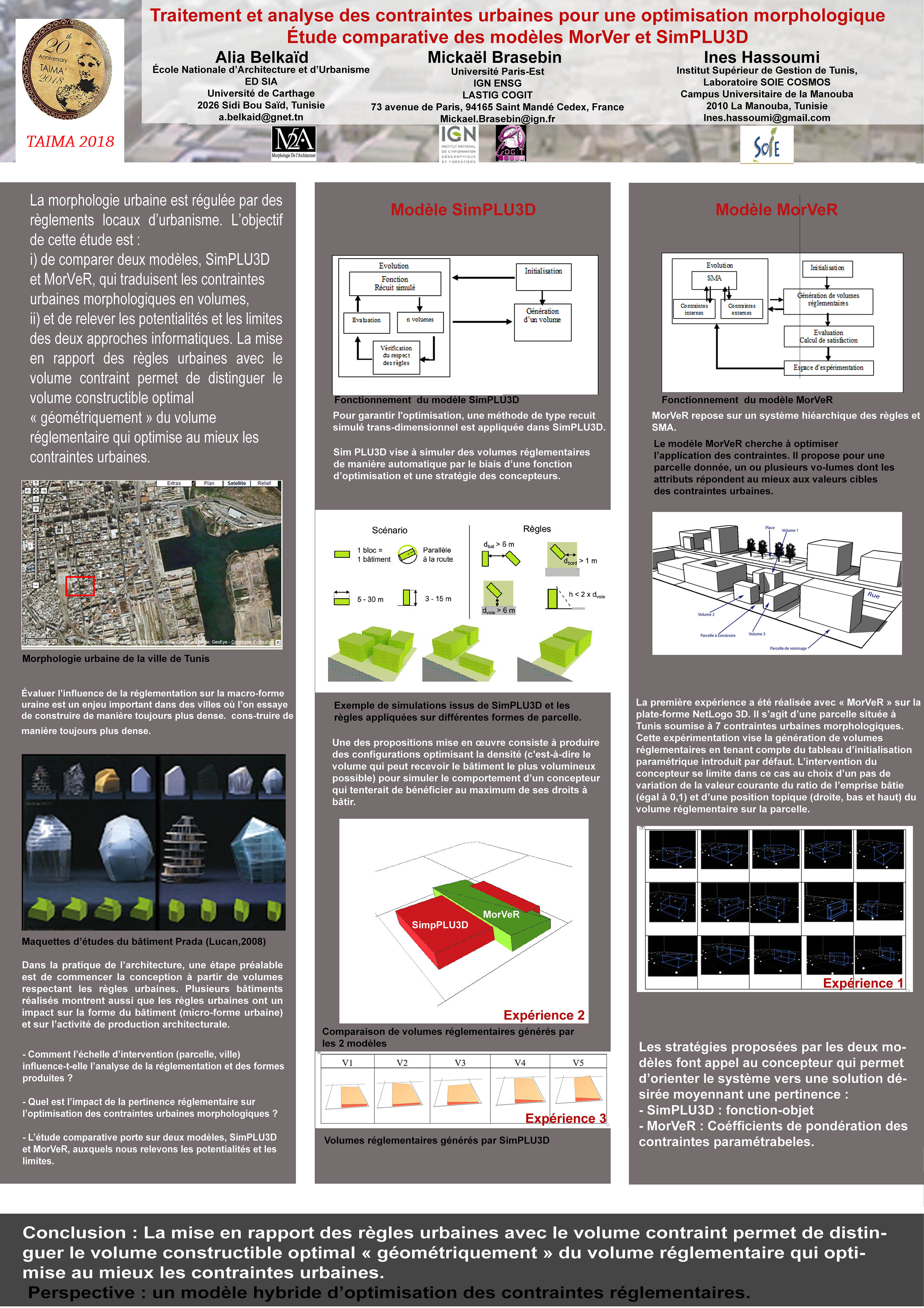
- Belkaid, A., M. Brasebin and I. Hassoumi (2018) Traitement et analyse des contraintes urbaines pour une optimisation morphologique Etude comparative des modèles MorVer et SimPLU3D, Proceedings of Taima 2018
[
Article, Poster].
- Olteanu-Raimond, A.-M., C. Duchêne, M. Brasebin, C. Dominguès, S. Mustière and M.-D. Van Damme (2017) From Relative to Absolute Location for Locating Victims in Mountain Area - A Preliminary Study, Proceedings
of the 28th International Cartographic Conference (ICC'17).
- Brasebin, M., S. Christophe, F. Jacquinod, A. Vinesse and H. Mahon (2016) Projet PLU++ : vers un Plan Local d’Urbanisme plus intelligible et plus participatif, Actes du Colloque International de Géomatique
et d'Analyse Spatiale (SAGEO 2016) (Prix du meilleur poster Sagéo 2016). [Article, Poster]
- Lhomme, S., M. Brasebin, A. Le Guilcher, O. Kaabi, S. Martel and B. Barocca (2016) Une application SIG pour l'optimisation de la collecte de déchets post-inondation, Actes du Colloque International de Géomatique
et d'Analyse Spatiale (SAGEO 2016). [Article, Poster]
Publications de transfert
- Brasebin, M., A. Ruas, A. Velten and G. Touya (2008)Tâche WP4 - Implémentation d'un algorithme de généralisation automatique de bâtiment 3D, Projet TerraNumerica. [Article]
Autres productions
- Brasebin, M. (2016) Simulating surface buildability to assess land prices based on 3D geodata and urban rules, EUROSDR annual repport 2015. [Article]